When is a trail run considered a hike?
- Ánika Warren-Smith
- Jan 8, 2022
- 5 min read
Updated: Nov 12, 2022
A month out of Melbourne's first long lockdown in 2020, I jumped at the opportunity to go on a group trail run at the Cathedral Ranges about 100km north-east of Melbourne. Never mind that physically I was probably not quite up to the task, the brain was more than willing to overlook that for some time in nature outside our 5km radius!

Whilst we had camped at the Cathedral Ranges State Park many times over the years, that was before I got into trail running and our kids were smaller so big hikes weren't generally on the agenda. I've been 'part' of a local trail running group called Wild Soles for a couple of years, and I emphasise the part because I had not yet managed to attend one of their runs. When I saw that they were heading to the Cathedral Ranges in December, I was determined to go.
The Cathedrals, as the state park is commonly known, are the remains of volcano that erupted some 373 million years ago leaving a crater 25km wide. The 7km ridge of tilted sedimentary rock reaches its highest point at Sugarloaf Peak (912m above sea level), rising impressively over the rural landscape. This land is the Country of the Taungurung People and the range is called Nanadhong in their traditional language.
Adventure Time!
A warm day was forecast and the 11km Southern Circuit route takes around 4-5hours to complete, so an early start it was. I consider anything starting with a '5' in the a.m. to be a bit rude, but in this case I was pretty excited to be getting up with the birds! By 8.30am here we all are, pumped and ready to go. Thanks to the random camping guy who took this photo for us :-)

Now, Wild Soles came here for their maiden run two years ago and from the stories I've heard, it's fair to say they were maybe a tad unprepared! So this time there was lots of information shared on our Facebook group of what to bring, the route map, estimated completion time, etc. I was only momentarily concerned when we were already checking the map a few minutes in...

But all good! From the Cooks Mill campsite, we ran up Tweed Spur Rd which is a 4WD track. It was uphill from the word go, which was a bit of a shock to the legs that had been restricted to a rather flat 5km radius during lockdowns. However this was strictly a 'no ego' run and there were thankfully lots of walking breaks. No use smashing ourselves early when there was A LOT more elevation ahead. After 1.5km we turned off onto Messmate Track. It was an indication of what's to come when the sign says it will take 1hr to do 2km...


This is the kind of track that I would love to run down! The gradient ranged mostly between 9-23% and the track was quite overgrown, so our pace was more on the walking side. It took us about 40 minutes to reach Sugarloaf Saddle (you can drive up to this point for a shorter route, just sayin') and from here it was on to the Canyon Track. You soon come to a fork in the track and if you head to the right, you can do a circuit that incorporates Wells Cave. This is apparently a very difficult hike. Trail Hiking Australia warns that "it is recommended for experienced hikers only as it is steep in places, requires a lot of rock scrambling and unassisted climbing and traverses some exposed ledges en-route."
Not this time. We went left and continued on the Canyon Track, which soon becomes steep and rocky. You start to get little glimpses of the view here and there, but you are largely concentrating on the path ahead.


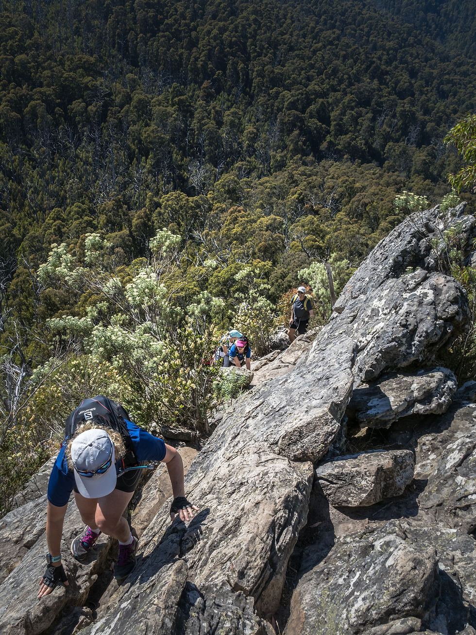
Then things started to get really interesting. Here I am (left, thanks Di!) contemplating exactly what sort of trail run involves climbing?
I mean, look at this from my perspective!

It's hard to describe how I felt as I climbed this rock face. I was concentrating pretty hard on not going over the edge, but also drinking in the fabulousness of where I was.

The most difficult section of climbing done, we stopped to chat to a couple waiting to go down. FYI - I think it was probably much easier to go up and that is certainly what is largely recommended.
As we waited for the others to join us, I snapped some shots with my Olympus E-M5III (below). I love that I can fit it into my hydration pack so easily and take it with me on these runs. Smartphones have certainly come a long way for photographic capabilities, but they still have their limitations.

All back together, it was a moment to celebrate what was an epic achievement of overcoming a fear of heights for two of our group. Kudos guys! We then pushed on for the last few hundred metres to Sugarloaf Peak.
Big views...

...in all directions.


After 2hrs of going up, it was time to refuel and this was a great spot for a snack.

'In-my-happy-place' selfie :-)

Now... time to go down and the descent along Razorback Track is just as challenging as the ascent for its technicality. The memorial plaque for a 15 year old boy who died whilst on a school hike in 1983 is a stark reminder of the need to really concentrate. On this section, I got too close to the soft edge of the track and went down pretty hard. Fortunately no real damage was done. Could have been much worse!
There was no running once again, as it was simply not possible unless you are part mountain goat or pro trail runner extraordinaire (of which I am neither)! Look at this elevation profile and then scroll through the galleries to see some of the images I captured on the way down.


I am always stopping for nature photos on my trail runs, some may call them rest stops ;-) There was much to see here: mintbush, Correas, snow gums, tea-tree (with very happy bees), paper daisies, lemon bottlebrush, trigger plants and fringe lilies to name just a few.


It's about 3km along Razorback from Sugarloaf Peak to the Farmyard and this took approximately 1.5hrs. From here we took Jawbone Track, which is super steep and includes many steps - as the sign says!

Our final section was St Bernard Track and now we were actually able to run for longer stretches. Everyone was feeling pretty good, there was lots of laughter and frivolity until... silence from behind.
Di rolled her ankle with less than 1km to go.
She felt something snap :-(

Taped up and with the aide of Ngân's podiatry skills and walking poles, she hobbled back to Cook's Mill and promptly sat in the cold river!

Such a pretty spot to soak weary muscles and torn ligaments.


My stats for the day were:
11.23km, moving time 4hr 21mins (+ 20min snack break at the peak)
pace 23:18/km
elevation 590m
As for food and fluids:
1 x banana
1 x 32GI sports chew
1 nut butter protein bar
almost 2L of water and a soft flask with 32GI Hydrate tablet
After a good long soak, we made tracks and finished off our recovery with a quick stop at Four Pillars in Healesville. Perfect end to a great day out!

The following day I woke up feeling like I'd done a full body workout, which was pretty much the case! I had such a great day and met some lovely, like-minded people. I hope to join them on another trail 'run', but sooner rather than later this time.
Oh and in answer to my initial question... If you've got the gear and look the part and run at some point along the way, then it most definitely is a trail run in my books :-)
Postscript
My knees were not very happy with me for several months after this outing, they started making noises they never used to make :-(
After some intense remedial massage and patiently re-building up muscle strength that was lost during lockdowns, I now feel like I could attempt this route again. The morale of the story - listen to your body and be realistic about what you can do!

Comments